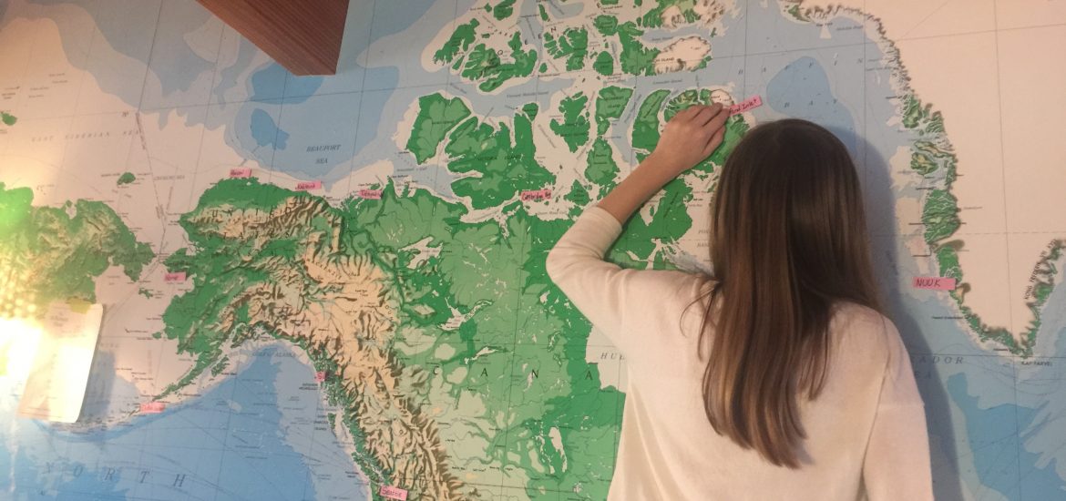
It is hard to tell you anything about our route because it is designed to be extremely flexible. This morning, I woke up and was told to lay out some sticky notes on “THE MAP”, which is this big map that we have on one of the walls of our house. It was conveniently there when we bought the house, which is funny, because we actually installed it on one of the walls of our old house. Anyway, I used a paper that my dad had written to mark the first few important stops we were going to make on our map. I have only marked the stops from here in Seattle to Nuuk, a small city that is the capital of Greenland. Here is a list of our major stops, and the distance between each one.
- Seattle to Sitka is about 900 miles. (Don’t worry, we’ll stop in anchorages or at harbors often on our way there). Mom, Savai, and I will get off the boat in Sitka to go home and skip the next few long crossings, which dad will do with some help from extra crew.
- Sitka to Dutch Harbor is about 1,100 miles without stopping. Dutch Harbor is a small fishing town in the Aleutian Islands.
- Dutch Harbor to Nome is about 600 miles. They probably will not stop along the way, so will be sailing overnight. This is probably where mom, Savai, and I will get back on Dogbark.
- Nome to Barrow is about 500 miles. Barrow is one of the largest Native Inuit cultural places that we will visit.
- Barrow to Tuktoyaktuk (took-toy-yook-took) is another 500 miles.
- Tuktoyaktuk to Cambridge Bay is about 650 miles.
- Cambridge Bay to Bellot Straight is 350 miles, plus 25 miles in the Straight. Bellot Straight is not an actual destination where we will stop.
- Bellot Straight to Pond Inlet is about 400 miles.
- Pond Inlet to Nuuk, Greenland is about 800 miles.
In all, the trip through the Northwest Passage is roughly 6,000 miles. From Nuuk, we don’t really know where we’re going, but we most likely will be able to be found wandering around in the middle of the Mediterranean Sea, Baltic Sea, or somewhere in the Atlantic Ocean.
Love it!
Spent a year on the Kenai Peninsula and 5 yrs north of Tuk before GPS. You’ll love it. Len
That seems like fun!
[…] via Dogbark’s Route (Talia’s Extremely Rough Draft) — Dogbark! […]
I think that is so cool! I love the map wall, and if I had space in my house, I would totally want one too. I am so exited to see what your boat looks like when it is all ready to travel in!
Thank you, Tali! We have a huge world map near our dining table, and I wanted to show Will, Anna and Jeff where you will be sailing. I know it’s a tentative path, but this is so helpful! We will stick red pushpins into our map to chart your travels. Will and Anna are so excited to keep track of you and Savai on your adventure!